Opportunity Atlas Defence Line Amsterdam municipality De Ronde Venen
For the municipality of De Ronde Venen, BOOM Landscape investigated how to improve the experience of a section of the UNESCO World Heritage site “De Stelling van Amsterdam”. Between the Uithoorn Fort and Nigtevecht Fort, this old military line of defence around Amsterdam needs a better future, and one that takes climate change into consideration. We developed a special atlas to visualise opportunities and solutions to urgent environmental issues.
UNESCO World Heritage
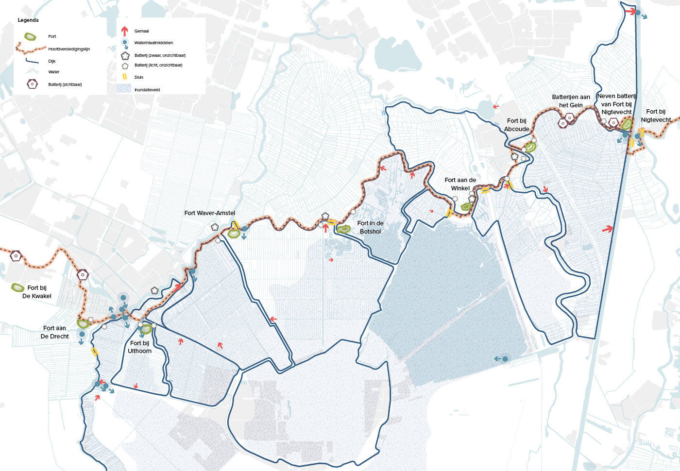
The historic Defence Line of Amsterdam is a 149-km long defensive ring around the capital city and was built between 1880 and 1920. It consists of 42 forts, 4 batteries, various dykes and sluices, plus an ingenious hydraulic system of inundation to flood surrounding fields. This extensive military site has been on the UNESCO World Heritage List since 1996.
Current experiences and accessibility
Several of the Defence Line’s original structures are still present in the landscape: the waterways, the forts, the main defence line and a number of lock-keepers houses, batteries and sluices. The forts are usually hidden in the landscape, as part of the defensive strategy, and they only become visible and tangible once you are in close proximity. It’s then that you see the clear military architecture with its thick walls and bombproof buildings.
Unfortunately, most of the forts are off-limits or poorly accessible to the public. The roads between the forts are also not entirely safe or appealing for slow traffic due to vehicular traffic. In addition, there are many missing links like clearly marked paths or routes that continue uninterrupted.
Urgent solutions needed
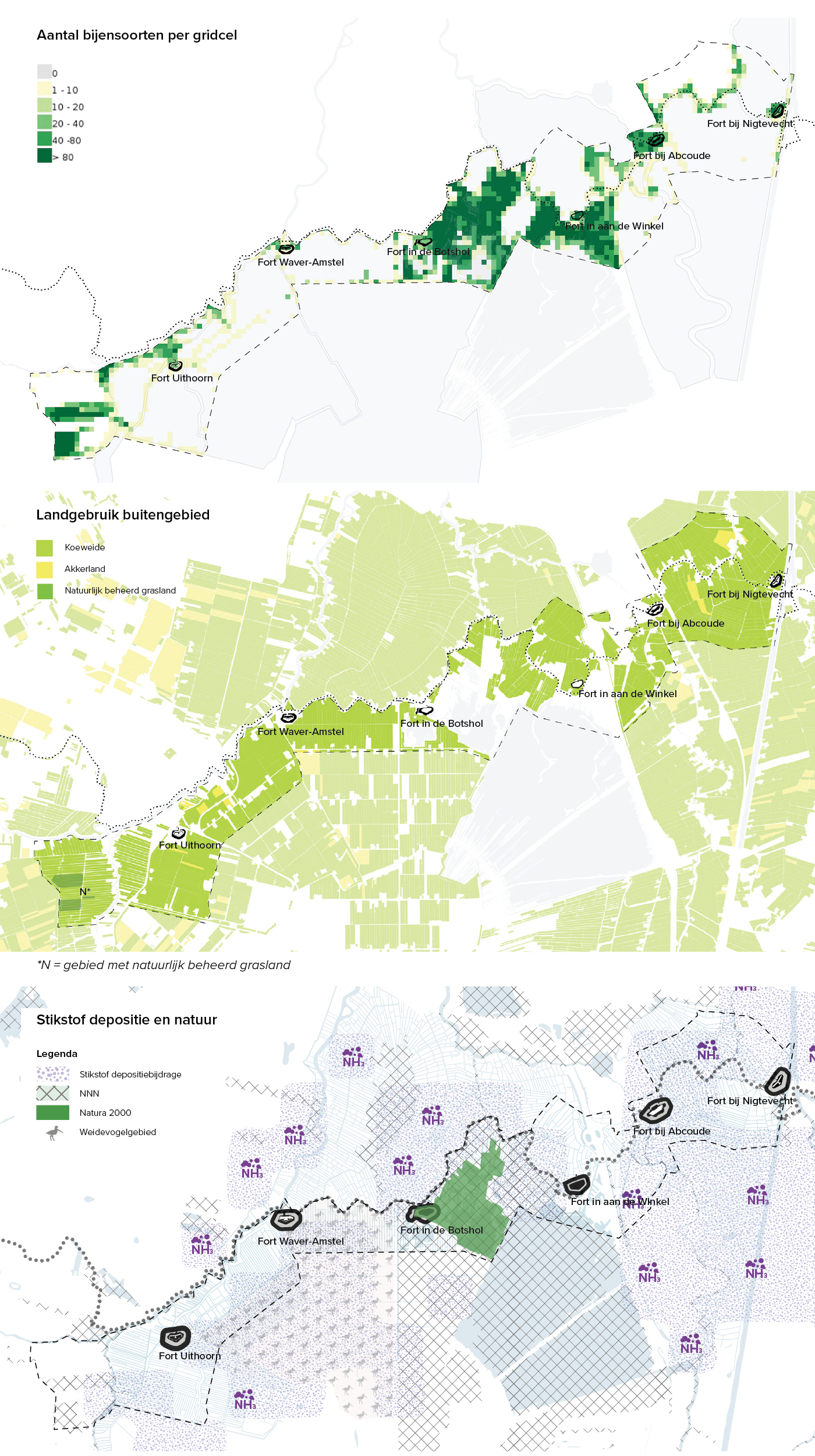
The land around the Defence Line is mostly peatland used for grazing cows today. This form of farming faces some serious environmental challenges, now and in the future. For example, when the groundwater is kept at an artificial level for the benefit of agriculture , the ground subsides due to oxidising peat, which subsequently emits CO2. Also, a monoculture of English ryegrass leads to poor biodiversity. The areas immediately next to the forts themselves do have ecological value as they are hotspots for wild vegetation.
Another issue is that intensive dairy farming creates nitrogen deposits (through emissions of ammonia) and this has a negative impact on nature areas like designated National Ecological Network (NEN) areas and the nearby nature reserve De Botshol (designated in ‘Natura 2000’). The deposits cause an excessive amount of nutrients in soil and water, and so plants that thrive on nutrient-poor soil, for instance, will disappear. The result is a more barren landscape and at the same time, wildlife that feeds off these rare plants will also lose their lifeline. Biodiversity in De Botshol is therefore suffering under severe pressure. Finally, fertilisers leaching into the water also negatively impacts the quality of plant and animal life, as well as the quality of surface water.
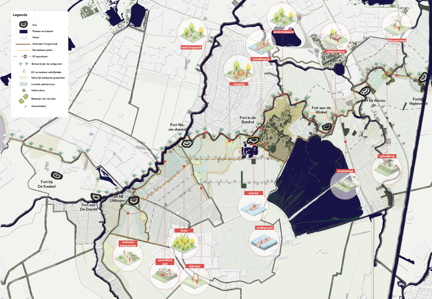
A Defence Line Park
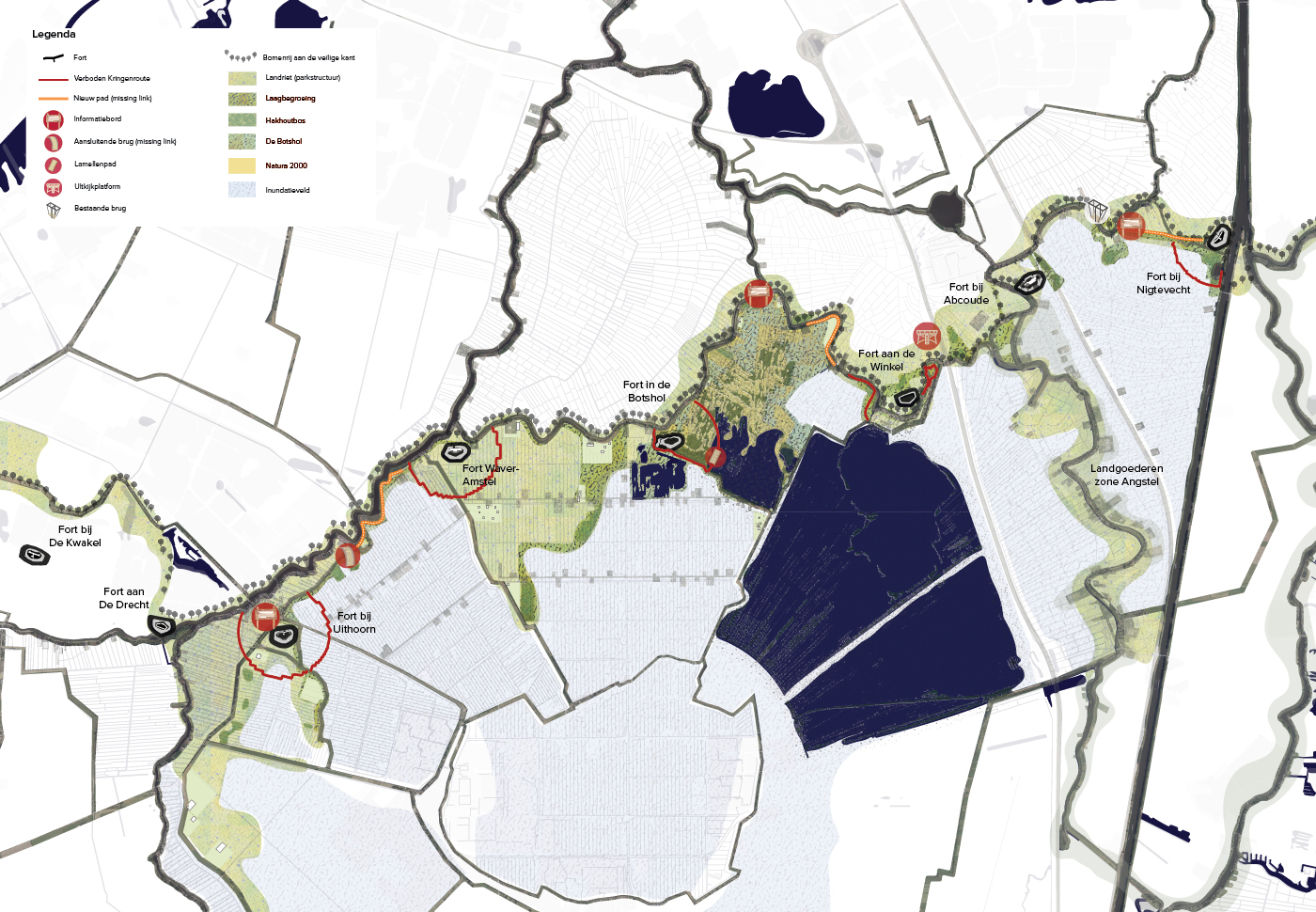
Our recommendation is to create a park structure at landscape scale to strengthen the network and recreational value of the landscape as a whole, and allowing visitors to experience the cultural history of the Defence Line as well. The existing framework of dykes, roads, green structures and rivers is already an excellent basis. The missing links can be resolved by adding bridges and connecting up trails. The Defence Line and inundation fields can become more visible by marking out a ‘Verboden Kringenroute’ (forbidden circular route): a path within the 600 metres surrounding the forts. This number has significance because the Kringenwet (Radius Law) stipulated that no buildings were to be erected within a 600-metre radius of every fort. A number of new markers in the landscape (like rows of trees, thickets, signage, park furniture and viewpoints) would help attract the attention of visitors and highlight the heritage of the area.
A balanced landscape
A further step in our investigation was to envision a healthier and balanced future for the existing landscape. In this vision the Defence Line becomes a natural link in the landscape and the surrounding dairy farmers would transition to a nature-inclusive form of farming. This means a landscape that is receptive to human visitors and new wildlife and plants, while also still being productive. The aim is a healthy and more biodiverse landscape with a resilient and robust ecosystem and clean, high-quality water.
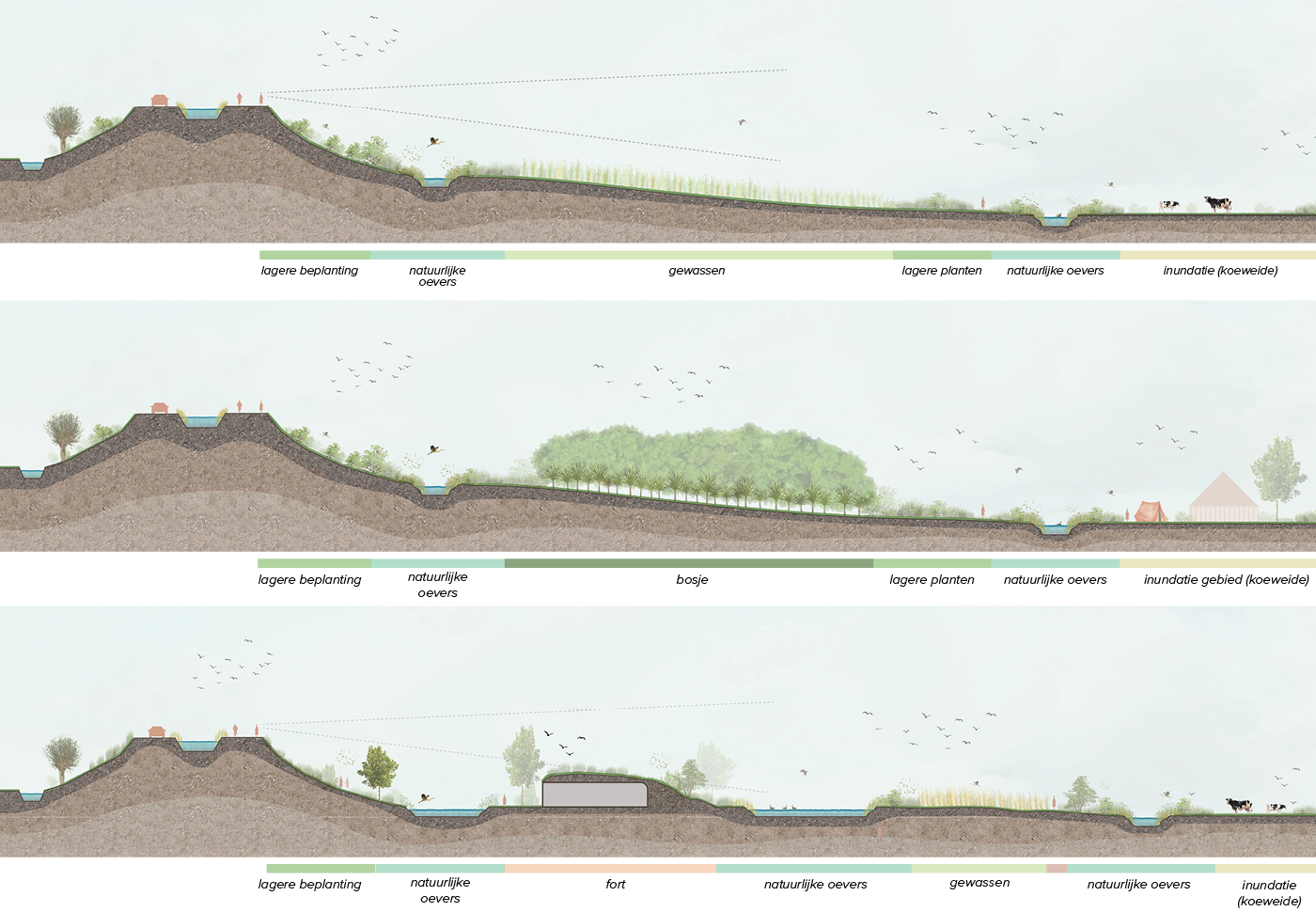
Green, beautiful, bocage
In this vision, the Defence Line becomes not only a more visible heritage structure, but also becomes a ribbon in the landscape that connects several currently isolated patches of nature in the area. This is achieved by adding more green between the polder and main line of defence, resulting in a more varied, biodiverse and recreationally attractive landscape. It would be a bocage of green lines and lush clusters, in which dense areas (like the higher fort embankments) alternate with open areas (like the flat fields where cows graze).
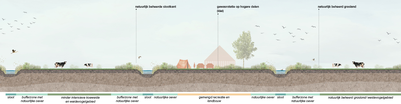
Nature-inclusive farming
A new style of farming would also strengthen the ecosystem and improve water and soil quality in the area. Dairy farming can continue here, but there would be fewer cows so as to decrease nitrogen emissions. In order for nature to have more natural space to grow and evolve, farmers would use less pesticides, manage the natural banks and substitute English ryegrass for flower-rich grasslands. Such a nature-inclusive cow pasture would furthermore create an attractive habitat for grassland birds.
Mixed use
Farmers could be compensated for shrinking their livestock by generating an income from a new agricultural product: biobased crops like wood, flax, hemp or bulrush – materials used in the building trade. And with the beautiful backdrop of this natural landscape there is the potential for a mini campground accompanied by the opportunity to hire a bike or canoe to tour the landscape from a different perspective.
Nature open to people
Finally we recommend to partially open up some nature areas that were previously closed to the public. Even during breeding season, by way of a special shielded path, it would be possible to hike through De Botshol without disturbing the birds. Adding a few shorter routes, like a sunken path at water level, also increases the recreational potential. Being open to recreational activities within nature helps to widen the appeal of nature and increase the awareness of the intriguing old military Defence Line of Amsterdam.