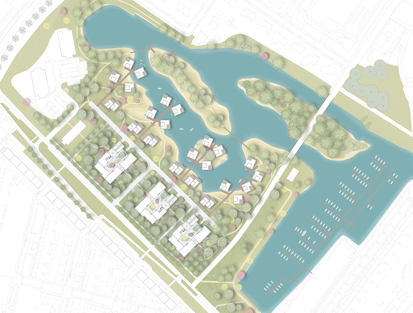
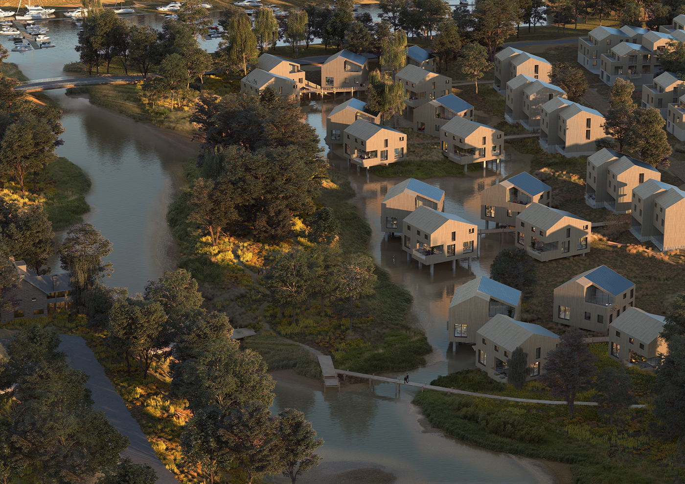
Plan Vleiland
A patch of land in Dordrecht, previously dense with schools, businesses and paved parking, is being transformed into a water-rich, natural landscape where the tides can come and go as they please. In the landscape plan for Vleiland, housing and habitats exist side by side. The new neighbourhood is a mere 5 minutes from the vibrant city centre, yet it is also a place where human life and wildlife find a new ecological balance. This is achieved by biodiversity and a fantastic offering of exploratory play in a shared environment.
Connected to nature
In Vleiland the human habitat is subordinate to the natural habitat, which means that all the buildings are being built in consideration of nature’s needs. They will be built with natural materials and low-tech installations for low-energy use and their facades will include space for nesting wildlife. Old paved surfaces having been removed, the freshwater tides are free to reign and a new network of footpaths invite people to explore the banks and islands to experience this unique landscape. A fun nature reserve for all ages will be created by arching willows, welly-wading areas, wobbly bridges, towing pontoons, fishing jetties and sandy play areas.
Biodiversity in a tidal landscape
The history of the area is what inspired the new landscaping plan for Vleiland. This was once a unique inland landscape of freshwater tides, with floodplains and willows, islands and mudflats, creeks and foraging birds: the Dordtse Wadden. Our plan restores some of the islands to the tributary De Vlij and restores the primal sense of a tidal landscape.
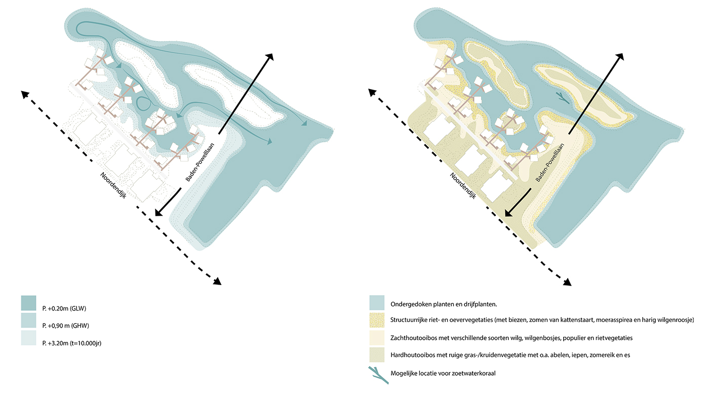
In the new plans, the tide can once again be experienced and, in addition, a local ecosystem will be revived and biodiversity reintroduced. By digging new channels and creating a series of new islands in place of the existing waterfront, a larger body of water will emerge, with headlands and longer banks. Water can then flow freely and bring sediment and nutrients to the vegetation on the islands and shoreline. This improves the water quality. And the long banks with fluctuating tides are good for amphibians, insects, fish and birds.
Gently sloping banks will stimulate natural growth and biodiversity in Vleiland. The gradient of the banks is so minimal that the transition from wet to dry will create perfect conditions for nature to flourish. All kinds of flora and fauna will be attracted to this area.
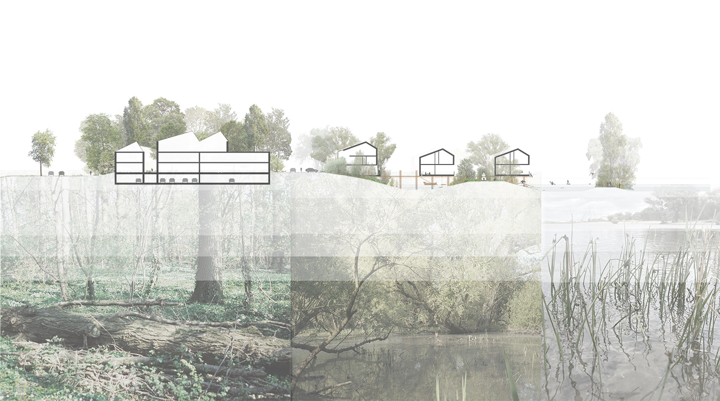
A gentle slope
The sands we are digging up to make room for water will be used to create a gradually ascending slope, a smooth transition between water and the dyke (Noordendijk). The urban plan builds on this feature and the three zones of water, banks and riparian woodland. Each zone will have their own ecological qualities, residential typologies and architectural style. The open water transitions into rushwoods and reed marches, and then to softwoods (varieties of willows) and finally hardwoods (e.g. elm trees, poplars and common oak). This creates a rich habitat for people, plants and wildlife. Moreover, the gradual transition in biotopes enhances the ecological quality of the area and will attract more and more wildlife to the land, it being a stepping stone to the nearby tidal wetlands of Biesbosch.
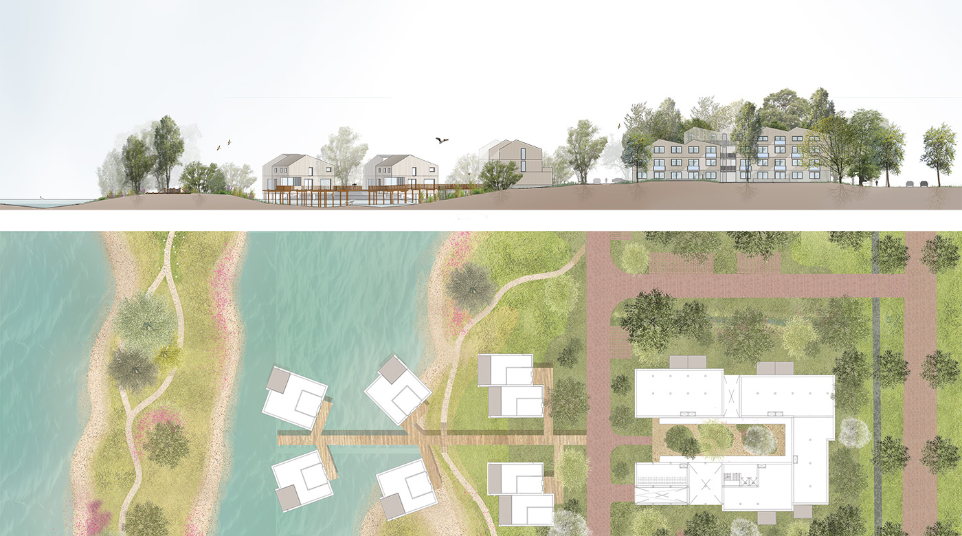
Tidal park in your backyard
We designed Vleiland to be a continuous landscape in order to give nature as much room to manoeuvre as possible. Wherever possible cars will be parked underground and the landscape will be not be fragmented into separate little green areas or fenced-in gardens. The terraces of the waterfront and shoreline homes have been deliberately incorporated within the architectural footprints. The luxury of Vleiland is that every resident has a freshwater tidal park as their backyard.
Space for ramblers and cyclists
Vleiland will be accessed via an intricate network of paths for cyclists and ramblers. Access to the neighbourhood by car is via the Noordendijk, where it is clear that drivers must proceed with caution as they are momentary users. Various routes take visitors – whether they’re wearing wellies or sandals – through an exciting and diverse landscape, from riparian woodlands to islands in the Vlij. All the footpaths connect up with existing trails around the area.

Climate-adpative and rain-receptive landscape
In Vleiland the new landscape is ready for the future and any potentially extreme weather conditions. The sloping banks, designed to accommodate the ebb and flow, also provide ample space for heavy rainfall. The mixture of plant species on the banks will help to hold water and prevent drought conditions. All the water and greenery surrounding the residential buildings will reduce heat stress during hot summers.
In addition, the new landscape is receptive to rainwater, which means it does not end up in the sewage system. Part of it will be collected for use as grey water in homes, such as for flushing toilets. Another part of it will be channelled into wadis: vegetated gullies alongside paths and roads that collect rainwater and gradually let it seep into the ground to join the groundwater that eventually flows into De Vlij. The wadis are connected by underground conduits so any heavy rainfall will not flood the area, but allow the water to continue flowing in the direction of De Vlij. Finally, all rainwater will easily infiltrate into the ground because the whole area has as little hard paving as possible.